EuroVelo developments and signage are gaining in importance in 2024, but faster progress is needed!
Main findings from the EuroVelo Route Development Status Report
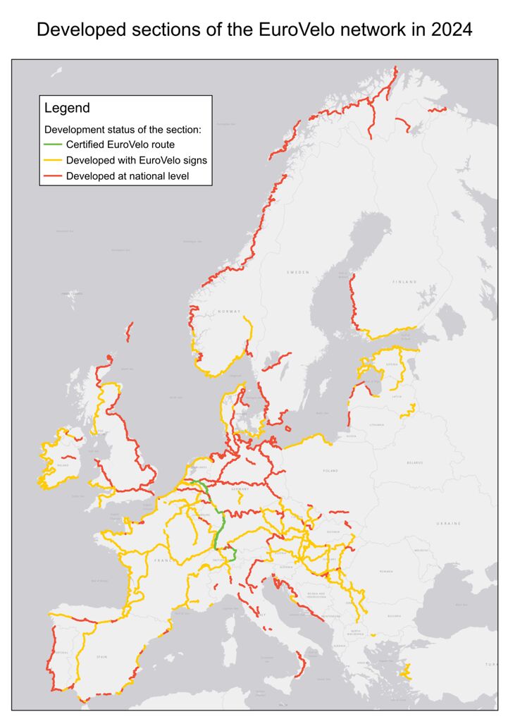
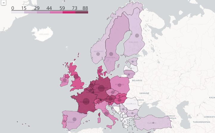
This year’s report indicates that 2,000+ km of EuroVelo routes were developed since 2023. Considering data corrections improving the accuracy of our analysis from the United Kingdom, Luxembourg, Sweden and France, the overall evolution is of +1% of EuroVelo development compared to 2023. Responsible authorities would need to develop around 5% of EuroVelo per year to reach the objective of 100% developed EuroVelo by 2030 (6,000 km per year).
On the other hand, this year has seen a surge in the level of signed routes, which coverage has increased by 5% compared to 2023 across the network, with almost 1,700 km of new sections with EuroVelo signs in 24 countries. In general, the progress of the last 3 years has been tremendous: +10,000 km in developed EuroVelo routes since 2021!
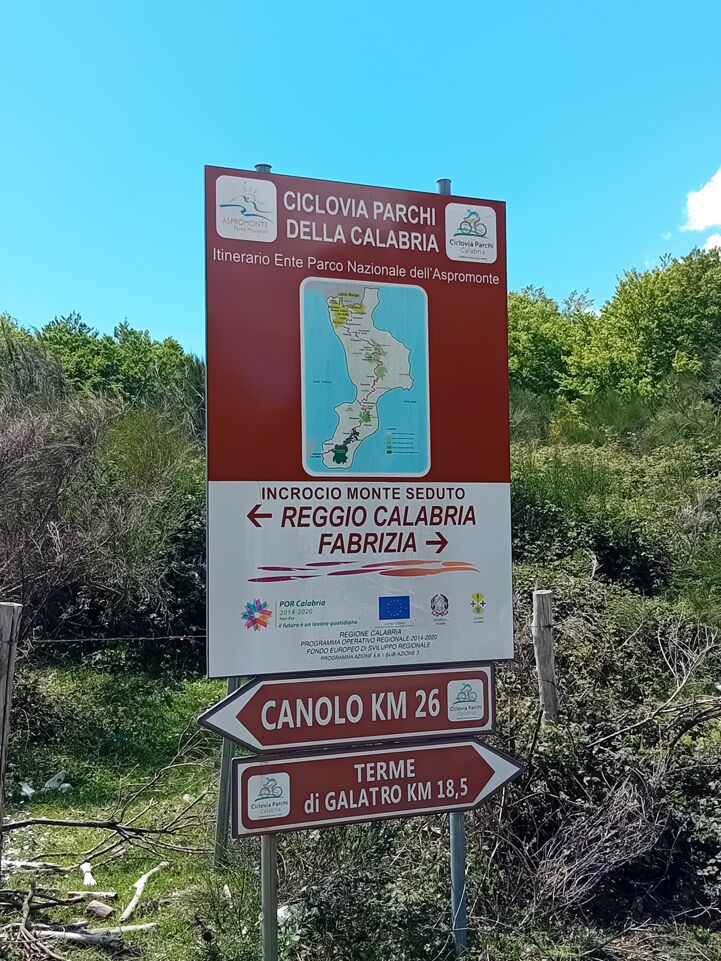
The countries that reported the most important developments in the past year are Serbia, Spain and Italy. Serbia completed its national EuroVelo network by signposting the whole 661 km of EuroVelo 11 – East Europe Route and improving cycle infrastructure along EuroVelo 6 – Atlantic-Black Sea and EuroVelo 13 – Iron Curtain Trail, thus climbing to the fourth position in the list of EuroVelo countries with the highest development rates. Spain developed 622 km of routes, mostly improving EuroVelo 8 – Mediterranean Route, but also EuroVelo 1 – Atlantic Coast Route. In turn, Italy improved EuroVelo 5 – Via Romea (Francigena) and EuroVelo 7 – Sun Route, partly modifying its itinerary to make it follow a well-developed route in Calabria.
The EuroVelo GIS database: assets and limitations
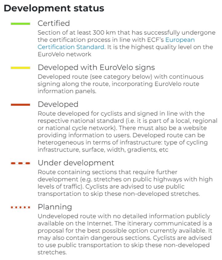
The EuroVelo Route Development Status Report’s analyses are based on data from the EuroVelo GIS database, which is the most complete and accurate source of information on EuroVelo routes and their development levels. In 2019, precise GPX tracks were collected for the very first time, as well as data on the development level of each “daily section” (around 50km long) of this 92,000-km network by ECF from National EuroVelo Coordination Centres. The EuroVelo GIS database considers five main categories of ‘Development status’, but it is no easy task to simplify the diversity of so many countries and realities, enough to make it fit into a database – so this classification has its limits, and the same development category can reflect heterogeneous cycling infrastructure types and qualities on the ground (i.e. in route component, width, surface, gradient, etc.). Since 2019, GPX tracks with their development categories have been updated at least once a year, thanks to the efforts made by ECF, National EuroVelo Coordination Centres (NECCs) and national contact points.
The EuroVelo GIS database allows to collect consistent data on EuroVelo route development levels across the entire continent, but it lacks detailed data on infrastructure types and qualities, as well as ground checks to ensure that the data is up-to-date and reliable. ECF’s cycle route quality methodology, the European Certification Standard (ECS), enables to consistently assess the cycling conditions. The ECS methodology is more and more used, but only 25% of the EuroVelo network has been surveyed with ECS by 2024, not enough to provide an overview of all the network.
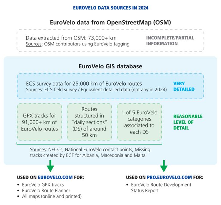
This year’s Report includes a section exploring what can be learnt on EuroVelo from OpenStreetMap (OSM). In particular, infrastructure types of EuroVelo routes on OSM confirm the hypothesis that there is a need to improve the quality of cycling conditions on most of the network (51%), even though this broad analysis may reflect heterogeneous realities. Another interesting finding is that OSM data analysis per EuroVelo route confirms the good quality of certain routes (e.g. EuroVelo 15 – Rhine Cycle Route and EuroVelo 19 – Meuse Cycle Route) but also indicates good quality levels for some routes if not considered in their entirety and excluding long under development sections (e.g. EuroVelo 2 – Capitals Route).
A complete EuroVelo network by 2030?
The EuroVelo Route Development Status Report 2024 estimates that a third of the EuroVelo network (30,135 km) is still awaiting developments, being now under development or at the planning stage. This means that responsible authorities all around Europe would have to develop around 6,000 km of EuroVelo per year to complete EuroVelo by 2030, as the EuroVelo Strategy aims for. All national stakeholders involved in the development of EuroVelo routes are encouraged to consult the newly released EuroVelo Development Guide, presented in this article, for recommendations and guidelines on how to boost developments.
Closer to 2030, it is likely that EuroVelo routes will be revised and that sections of the network where no development plans are realistically foreseen will be removed from the network. But to pave the way for this revision, ECF will continue to improve the accuracy of the EuroVelo GIS database and to gather more precise data on EuroVelo routes’ development levels and infrastructure types and qualities.
Written by Florence Grégoire
Cover image: new developed itinerary for EuroVelo 7 - Sun Route in Calabria, Italy, provided by FIAB